Introduction
Monitoring crop health has always been one of agriculture’s most important and most challenging tasks. Farmers traditionally rely on manual field scouting, visually inspecting crops for signs such as yellowing leaves, wilting, discoloration, or pest damage. While this method remains valuable, it is inherently reactive. By the time visible symptoms appear, physiological stress may already have reduced growth, yield, or crop quality.
Remote sensing has fundamentally changed how scientists observe vegetation. Instead of relying solely on visible colour, modern imaging systems measure how plants interact with different wavelengths of light. Among these techniques, the Normalized Difference Vegetation Index (NDVI) has become one of the most widely adopted methods for assessing vegetation health, supporting applications ranging from precision agriculture and forestry to drought monitoring and satellite-based Earth observation (NASA Earth Observatory, 2023; USGS Landsat Missions, 2024). NASA, the United States Geological Survey (USGS), and the European Space Agency all use NDVI-derived products to monitor vegetation at regional and global scales (NASA Earth Observatory; Copernicus Sentinel-2 Mission).
Despite its widespread scientific adoption, field deployment has historically been limited by hardware costs. Commercial multispectral cameras capable of accurately separating spectral bands require specialized optics, carefully calhealthyibrated sensors, and factory characterization. While these systems deliver excellent scientific accuracy, they often remain prohibitively expensive for educational institutions, student researchers, small farms, and engineering prototypes.
Recent advances in embedded computing, open-source software, and affordable imaging hardware have created an alternative path. Rather than reproducing laboratory-grade instruments, engineers are increasingly investigating low-cost imaging pipelines that approximate multispectral measurements using conventional cameras, inexpensive optical filters, and software-based image processing. Although these systems cannot replace professional scientific instruments, they significantly reduce the barrier to experimentation and practical deployment.
This article explores the engineering principles behind affordable NDVI imaging systems, explaining how they work, the compromises they introduce, and how they can be integrated with modern computer vision techniques to support accessible plant health monitoring.
What NDVI Actually Measures
The effectiveness of NDVI originates from a fundamental property of plant biology rather than artificial intelligence. Healthy vegetation interacts with visible and near-infrared light in a highly predictable manner because of the physical structure of leaves and the chemistry of photosynthesis (Rouse et al., 1974; Tucker, 1979).
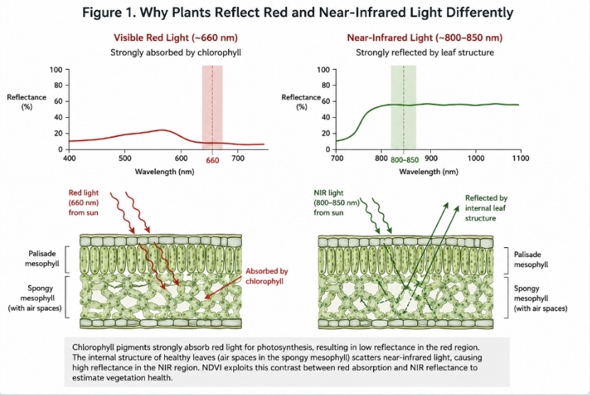
Chlorophyll, the pigment responsible for photosynthesis, strongly absorbs blue and red wavelengths of visible light to convert solar energy into chemical energy. Green wavelengths are absorbed less efficiently and therefore reflected back toward the observer, explaining why healthy vegetation appears green.
Near-infrared radiation behaves very differently. Instead of interacting primarily with chlorophyll, it interacts with the internal cellular structure of the leaf. Healthy leaves contain spongy mesophyll tissue with numerous air spaces that scatter near-infrared radiation extremely efficiently. As a result, vigorous vegetation reflects a large proportion of incoming near-infrared light while simultaneously absorbing most incoming red light.
When plants become stressed by drought, nutrient deficiency, disease, or pest damage, these internal structures begin to deteriorate. Reflectance in the near-infrared region decreases, often before visible colour changes become noticeable. This physiological response allows NDVI to detect stress earlier than visual inspection alone.
NDVI quantifies this difference by comparing reflected near-infrared and red light using the equation:
NDVI = (NIR − Red) / (NIR + Red)
Because the index is normalized, it reduces sensitivity to overall lighting intensity and produces values between approximately -1 and +1. Healthy dense vegetation commonly produces values between 0.6 and 0.8, while sparse vegetation typically falls between 0.2 and 0.5. Bare soil generally produces values near 0.1–0.2, whereas water and artificial surfaces often generate values close to zero or negative. These ranges vary depending on crop type, growth stage, atmospheric conditions, and sensor characteristics.
Importantly, NDVI does not diagnose diseases directly. It measures changes in vegetation vigor. Determining whether reduced vigor results from drought, fungal infection, nutrient deficiency, or insect damage requires additional contextual information or complementary sensing methods.
How Commercial NDVI Systems Work
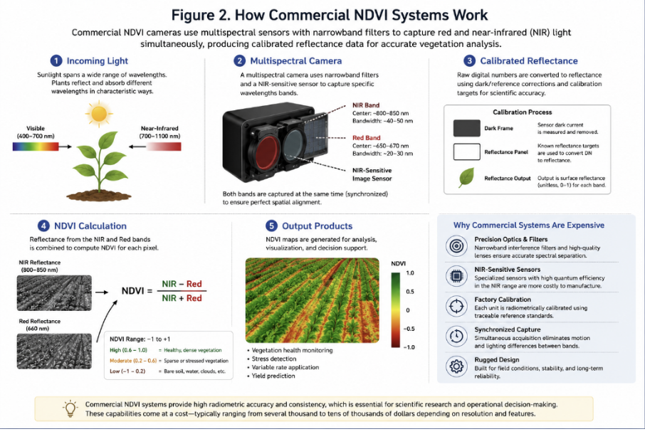
Commercial NDVI systems are fundamentally multispectral imaging systems. Unlike conventional cameras that capture broad red, green, and blue colour channels, multispectral cameras isolate narrow wavelength bands using precisely engineered optical filters and calibrated image sensors.
Many professional systems simultaneously capture visible red wavelengths near 660 nm and near-infrared wavelengths around 800–850 nm. Factory calibration ensures each spectral band accurately represents surface reflectance rather than simply pixel brightness. This distinction is crucial because vegetation indices rely on radiometric consistency across different lighting conditions and observation dates.
Professional multispectral cameras also synchronize image capture across multiple sensors. Since both spectral channels are acquired simultaneously, they avoid motion-induced registration errors that commonly affect lower-cost systems. Additional calibration procedures compensate for lens distortion, sensor response differences, and illumination variability.
These capabilities explain why scientific multispectral cameras remain indispensable for research-grade applications such as crop phenotyping, environmental monitoring, and satellite validation. However, the engineering complexity required to achieve this level of precision substantially increases system cost.
Can NDVI Be Built More Affordably?
The central engineering question is not whether low-cost hardware can replace scientific multispectral cameras, it cannot. Rather, the question is whether useful vegetation information can be extracted using significantly less expensive components.
Affordable NDVI systems take advantage of a simple observation: conventional image sensors are inherently sensitive to near-infrared radiation. Consumer cameras normally include an infrared-blocking filter to improve colour accuracy for photography. Removing or replacing this filter allows the sensor to detect both visible and near-infrared light.
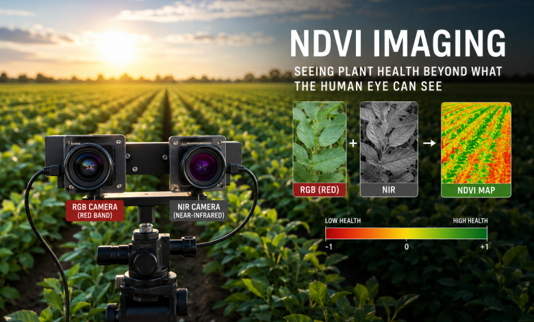
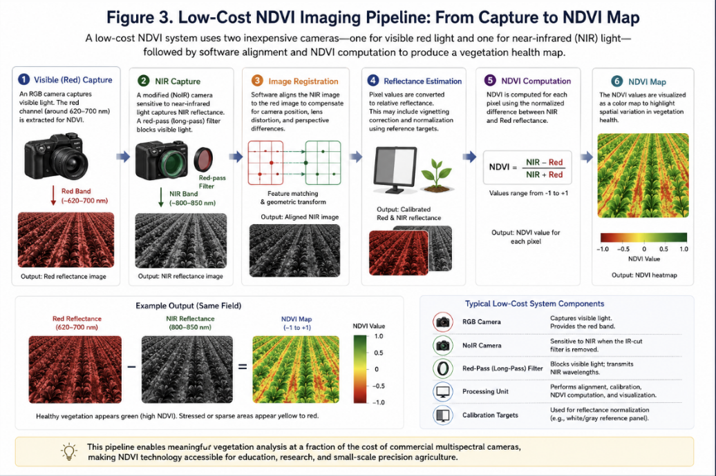
Instead of manufacturing specialized multispectral sensors, engineers can combine an infrared-sensitive camera with inexpensive optical filters that preferentially transmit near-infrared wavelengths. A second conventional RGB camera captures visible imagery, and software aligns the two images before calculating NDVI.
This approach shifts complexity away from hardware manufacturing and into software, where calibration, image registration, and reflectance estimation compensate for simpler optical components.
Building a Low-Cost NDVI Imaging Pipeline
A typical low-cost imaging pipeline consists of five major components.
The first component is a conventional RGB camera responsible for capturing visible red reflectance.
The second is an infrared-sensitive camera, often referred to as a NoIR camera, that lacks the infrared-blocking filter found in standard consumer cameras.
A red-pass optical filter is then placed over the infrared-sensitive camera. This filter blocks much of the visible spectrum while allowing near-infrared radiation to reach the sensor, approximating the spectral response required for NDVI calculations.
Because the two cameras occupy different physical positions, their images cannot be compared directly. Computer vision techniques perform image registration, aligning corresponding pixels through feature matching or geometric transformations before vegetation indices are calculated.
Finally, software computes NDVI for every pixel, generating a false-colour vegetation map that highlights relative differences in plant vigor. The resulting output can then be combined with additional computer vision algorithms for automated analysis.
Engineering Challenges
Although conceptually straightforward, affordable NDVI imaging presents several engineering challenges.
Image alignment is perhaps the most significant. Even small differences in camera position, viewing angle, or lens distortion can produce inaccurate NDVI values if corresponding pixels are misaligned.
Calibration presents another difficulty. Commercial multispectral systems undergo factory radiometric calibration, whereas low-cost systems typically rely on empirical calibration using reflectance targets or reference panels.
Lighting conditions introduce additional uncertainty. Changes in solar angle, cloud cover, and atmospheric conditions affect measured reflectance, making consistent data collection more challenging than laboratory testing.
Camera synchronization also matters. If wind moves leaves between sequential image captures, corresponding pixels may represent different physical locations, reducing index accuracy.
Finally, consumer camera sensors exhibit broader and less predictable spectral response curves than scientific multispectral sensors, limiting measurement precision.
Computer Vision Beyond NDVI
NDVI provides a valuable measure of vegetation vigor, but it does not identify the underlying cause of plant stress. This limitation has encouraged researchers to combine vegetation indices with modern computer vision models.
Object detection networks such as YOLOv8 can identify individual plants or leaves while simultaneously classifying visible symptoms including chlorosis, lesions, pest damage, or wilting. Instead of relying solely on spectral information, these models analyze spatial patterns, texture, colour variation, and object geometry.
Combining NDVI with computer vision produces complementary information. NDVI can highlight physiological stress before visible symptoms emerge, while object detection models provide contextual interpretation once visual symptoms become apparent.
This multimodal approach is increasingly appearing in agricultural robotics, autonomous crop scouting, and precision farming research because it integrates spectral sensing with advances in deep learning.
Current Limitations
Despite growing accessibility, affordable NDVI systems should not be viewed as replacements for scientific multispectral cameras.
Their spectral bands are approximations rather than precisely defined wavelength measurements. Camera sensors differ between manufacturers, optical filters exhibit varying transmission characteristics, and calibration procedures remain less rigorous than laboratory-grade instruments.
Furthermore, NDVI itself has known limitations. Dense vegetation can saturate the index, reducing sensitivity in highly productive crops. Soil brightness, shadows, and atmospheric conditions may also influence measurements.
Consequently, low-cost systems are best understood as engineering tools for education, prototyping, and preliminary field monitoring rather than instruments for quantitative scientific measurement.
The Future of Affordable Agricultural AI
The convergence of embedded computing, open-source robotics, and machine learning is rapidly expanding what affordable agricultural sensing can achieve.
Small AI computers capable of running neural networks directly at the edge now enable real-time inference without cloud connectivity. Open-source frameworks such as ROS 2, OpenCV, and PyTorch have lowered software development barriers, while advances in efficient object detection models continue reducing computational requirements.
As publicly available agricultural datasets continue to grow and edge hardware becomes more capable, affordable sensing systems will likely become increasingly practical for education, research, and small-scale agricultural deployments.
Rather than replacing professional multispectral instruments, these systems expand access to technologies that were previously limited to specialized laboratories and well-funded research programs.
Conclusion
NDVI remains one of the most influential tools in remote sensing because it transforms simple measurements of reflected light into meaningful indicators of vegetation health. While professional multispectral cameras continue to provide the highest levels of scientific accuracy, recent advances in imaging hardware, embedded computing, and computer vision have demonstrated that useful plant health monitoring can be achieved using significantly more affordable components.
The true innovation lies not in replacing scientific instrumentation but in democratizing access to it. By combining inexpensive cameras, optical filters, software-based calibration, and modern machine learning techniques, engineers are creating systems that make precision agriculture increasingly accessible to students, researchers, and practitioners worldwide.
Affordable NDVI imaging therefore represents more than a cost-saving exercise. It illustrates how thoughtful engineering can bridge the gap between laboratory research and practical deployment, enabling broader participation in agricultural innovation while laying the foundation for the next generation of intelligent farming technologies.
References
- Rouse, J. W., Haas, R. H., Schell, J. A., & Deering, D. W. (1974). Monitoring Vegetation Systems in the Great Plains with ERTS. Third Earth Resources Technology Satellite Symposium, NASA SP-351.
- Tucker, C. J. (1979). “Red and Photographic Infrared Linear Combinations for Monitoring Vegetation.” Remote Sensing of Environment, 8(2), 127–150. DOI: 10.1016/0034-4257(79)90013-0.
- NASA Earth Observatory. Measuring Vegetation (NDVI & EVI).
- U.S. Geological Survey. Landsat Normalized Difference Vegetation Index (NDVI).
- Xue, J., & Su, B. (2017). “Significant Remote Sensing Vegetation Indices: A Review of Developments and Applications.” Journal of Sensors, 2017.
- OpenCV Documentation. Feature Detection and Image Registration.
- Redmon, J., et al. (YOLO) and the Ultralytics YOLO documentation for modern YOLOv8 implementation details.
- Public Lab. DIY Near Infrared Photography and NDVI (community documentation on low-cost NIR imaging concepts).