
The data collected will help enhance understanding of habitats, geohazards, and oceanographic conditions across 13,000 square nautical miles in the northwestern Pacific Ocean.
WASHINGTON, Feb. 24, 2026 /PRNewswire/ — Woolpert and Saildrone have partnered to acquire and process bathymetric survey data for the National Oceanic and Atmospheric Administration’s Ocean Exploration and Office of Coast Survey in support of safe navigation and national ocean mapping initiatives, including the National Strategy for Mapping, Exploring, and Characterizing the United States Exclusive Economic Zone and Seabed 2030 initiative.

The Mariana Islands’ strategic location and vast marine ecosystems make it a critical region for monitoring and analysis. The data will be used by NOAA to help enhance its understanding of sensitive habitats, marine geohazards, oceanographic conditions, seafloor composition, and ecosystem management within the U.S. exclusive economic zone in the vicinity of the Mariana Islands. It will also help expand taxonomic reference libraries for understudied marine organisms.
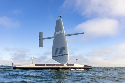
Woolpert, a leading provider of lidar and sonar bathymetry data, was selected by NOAA to map the seafloor off the eastern coast of the Mariana Islands. The firm partnered with Saildrone, which will use a 20-meter Saildrone Surveyor uncrewed surface vehicle designed for persistent maritime intelligence, surveillance, reconnaissance, and deep-ocean mapping.
The Saildrone Surveyor operates autonomously and delivers high-resolution bathymetric data in the world’s most challenging environments. Powered by a high-efficiency diesel engine augmented by the patented Saildrone Wing, the vehicle leverages auxiliary wind energy to maximize fuel efficiency. This dual-source power architecture enables the extreme range and persistence necessary for autonomous, long-duration deep-water ocean mapping.
This month, Saildrone began collecting high-resolution bathymetric data across the 13,000-square-nautical-mile area of the northwestern Pacific Ocean. Saildrone will transmit the data to Woolpert in near-real time for processing and final delivery.
“The seafloor mapping and exploration data that the Surveyor collects around the Mariana Islands will close critical bathymetric gaps in the United States’ exclusive economic zone,” said Brian Connon, vice president of ocean mapping at Saildrone. “The Surveyor’s ability to remain at sea for months at a time, regardless of weather conditions or sea state, makes it an ideal platform to carry out this vital work. Saildrone is proud to be working with both Woolpert and NOAA in these crucial efforts to better understand our ocean, marine resources, and ecosystem.”
Woolpert Maritime Market Director Dave Neff said the partnership shows how autonomous technologies are transforming the acquisition of hydrographic data for deep-ocean exploration.
“By integrating Saildrone’s mission portal with Woolpert’s automated survey production environment, we gain real-time visibility into acquisition progress and data quality — especially in deep-water regions that were once difficult and costly to access,” Neff said. “This collaboration shows how uncrewed systems and smart partnerships can expand what’s possible in ocean mapping.”
The contract is underway and is expected to conclude in May 2026.
About Woolpert
Woolpert is a global leader in architecture, engineering, and geospatial (AEG) services, with over a century of experience driving innovation and delivering impact. We fuse deep technical expertise with a forward-thinking mindset to solve complex challenges across the public, private, and government sectors. Woolpert is proud to be a certified Great Place to Work, a Top 25 Building Design+Construction firm, a Top 50 Engineering News-Record Design firm, and a Global Top 100 Geospatial company. Woolpert operates from more than 75 offices across five continents—building smarter, more resilient communities around the world. Learn more at woolpert.com.
About Saildrone
Saildrone is a maritime defense company with a relentless passion for performance. Built to operate in the world’s harshest environments, Saildrone’s autonomous systems deliver payload effects and persistent, wide-area intelligence, enabling informed decisions across the spectrum of defense missions. Harnessing AI, advanced sensor suites, and renewable power for unmatched endurance at sea, Saildrone delivers superior multi-domain impact—from power projection to persistent ISR to real-time threat detection and tracking—while reducing cost and risk. With proven operational success across the world’s oceans, Saildrone is advancing the frontier of autonomous maritime operations to give decision-makers and warfighters the enduring advantage to outpace adversaries today and build tomorrow’s most decisive capabilities.
Media Contact
Lynn Rossi
312-837-2017
![]()
![]() View original content to download multimedia:https://www.prnewswire.com/news-releases/woolpert-and-saildrone-partner-to-deploy-surveyor-uncrewed-surface-vehicle-for-noaa-seafloor-mapping-project-off-coast-of-mariana-islands-302695164.html
View original content to download multimedia:https://www.prnewswire.com/news-releases/woolpert-and-saildrone-partner-to-deploy-surveyor-uncrewed-surface-vehicle-for-noaa-seafloor-mapping-project-off-coast-of-mariana-islands-302695164.html
SOURCE Woolpert
