LOS ANGELES & BENGALURU, India–(BUSINESS WIRE)–Pixxel, a space technology company building the world’s highest-resolution hyperspectral satellite constellation, today announced that its three Firefly satellites have successfully captured and downlinked their ‘First Light’ images – setting a new benchmark as the world’s highest-resolution hyperspectral images!

![]()
![]()
With all three satellites having completed commissioning successfully and in perfect working condition, this marks a significant milestone in the company’s aim to deliver cutting-edge Earth observation capabilities. Launched in January 2025 aboard SpaceX’s Transporter-12, the three Firefly satellites are beaming down images at an unprecedented 5-meter resolution across 150+ spectral bands with 40 km swath width. The released images highlight unseen details of three areas, one from each satellite.
The newly-released First Light images highlight three ecologically and economically significant regions, each captured by a different Firefly satellite:
-
River Ganga, India (Firefly 3)
- Showcases the river’s braided channels, floodplains, and surrounding farmland.
- The hyperspectral detail reveals subtle variations in soil moisture and vegetation health—critical for farmers and water resource managers.
-
Saloum River Delta, Senegal (Firefly 2)
- Highlights the intricate waterways and wetlands of the delta region.
- This data can be used to monitor changing coastlines, track salinity levels, and protect fishery resources.
-
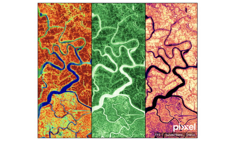
Sundarbans, India (Firefly 1)
- Focuses on one of the world’s largest mangrove forests.
- The satellite’s high-resolution spectral imagery helps researchers track forest health, detect mangrove stress, and plan conservation strategies.
By capturing far more detail than traditional satellites and spanning a comprehensive range of spectral bands, Pixxel’s Firefly satellites unlock transformative new applications. Agriculture operators can pinpoint nutrient deficiencies, detect early signs of crop stress, and minimize water usage by monitoring evapotranspiration rates. Climate monitoring agencies can observe shifts in carbon capture by forests, detect emissions hotspots like methane leaks, and track deforestation in near real time. Mining companies can use spectral signatures to locate mineral-rich deposits or monitor tailing ponds for environmental compliance. And disaster response teams can rapidly assess flood- or fire-damaged areas, enabling swifter, better-targeted relief efforts.
“We’re proud to unveil these pioneering images from Firefly, each pixel a vital clue in our quest to decode the Earth’s complexities,” said Awais Ahmed, Founder and CEO, Pixxel. “With each new hyperspectral satellite, we are making the invisible visible, bringing planetary-scale intelligence to industries that need it most. By illuminating invisible signals — whether it’s detecting pollutants in the atmosphere or providing early warning of crop diseases in far-flung fields — we can now act with foresight and precision. These images are proof that the future of Earth observation, and our planet’s wellbeing, is brilliantly within reach.”
Pixxel’s recent partnerships span diverse sectors, with leading organizations such as NASA and the National Reconnaissance Office (NRO) collaborating on the company’s next-generation Earth observation technology. This solidifies Pixxel’s broader mission to create a “health monitor for the planet” by equipping stakeholders with high-fidelity, real-time insights into Earth’s surface and atmosphere.
The success of the first three Firefly satellites accelerates Pixxel’s roadmap toward deploying a full-scale hyperspectral constellation by 2026. Three additional Firefly satellites are scheduled to launch before mid 2025. High-fidelity images from these satellites will spectrally fingerprint the Earth and set a new standard in hyperspectral intelligence, reinforcing Pixxel’s mission of building a health monitor for the planet and transforming critical decision-making.
About Pixxel
Pixxel is a space data company and spacecraft manufacturer redefining Earth observation with hyperspectral imaging. With the successful launch of its first three commercial hyperspectral satellites ‘Fireflies,’ Pixxel is building a constellation of a total of 18-24 satellites designed for a daily revisit frequency anywhere on Earth. This constellation will deliver the world’s highest-resolution hyperspectral imagery, enabling industries to detect, monitor, and predict critical global phenomena across agriculture, oil and gas, mining, environment, and other sectors with 5m resolution and 50x richer detail compared to conventional satellites.
Beyond Earth observation, Pixxel is also manufacturing satellites, advancing cutting-edge spacecraft technology for various applications. Its in-house Earth Observation Studio, Aurora, is helping users seamlessly analyze satellite imagery, making hyperspectral data more accessible and actionable.
Pixxel has raised $95 million from M&G Catalyst, Glade Brook Capital Partners, Aditya Birla Ventures, Google, Lightspeed, Radical Ventures and others. For more information, visit www.pixxel.space or follow Pixxel on Twitter and LinkedIn.
Contacts